


Met Eireann issues urgent weather warning for six counties after sudden change in Ireland forecast
The potential impacts of the heavy rain listed by Met Eireann include localised flooding, difficult travelling conditions and outdoor events being impacted
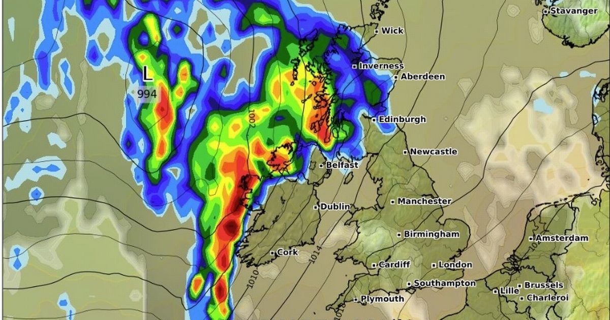
Met Eireann has issued an urgent yellow status weather warning for six counties.
The alert is for "heavy and persistent rain" and applies to counties Cork; Kerry; Donegal; Galway; Leitrim and Mayo.
Met Eireann issued the warning shortly before 10.30am on Sunday - the alert will be active between 3.00pm on Monday and 10.00am on Tuesday.
READ MORE - Teenager dies in horror collision as man is rushed to hospital
READ MORE - Former Irish President candidate slashes price of speedboat for 'quick sale'
The potential impacts of the heavy rain listed by Met Eireann include localised flooding, difficult travelling conditions and outdoor events being impacted.
Writing on X, Alan O'Reilly of Carlow Weather, said: "More wet and windy weather coming Monday night into Tuesday morning with some high rainfall totals in parts of West, over 40mm possibly with risk of local spot flooding. Clearing East Tuesday afternoon.
National Outlook
Overview: Continuing unsettled with rain or showers at times. Temperatures will be close to average for late August.
Monday night will become wet and windy as rain spreads eastwards to all areas. Rain will be heaviest in west Munster, Connacht and Ulster with spot flooding possible. Lowest temperatures of 14 to 16 degrees with fresh, gusty southerly winds.
Tuesday will start off wet with further rain. The rain will gradually clear eastwards with sunshine and a few showers following. Highest temperatures of 17 to 21 degrees with moderate southerly winds, becoming west to southwesterly as rain clears. Tuesday night will be dry in most areas with some clear spells. Showery rain will develop in the west by morning. Lowest temperatures of 10 to 13 degrees in light to moderate breezes.
On Wednesday, showers or longer spells of rain will spread slowly eastwards, possibly heavy at times. The best of any drier brighter periods will be in the east and southeast. Highest temperatures of 16 to 19 degrees, with light to moderate southerly winds. There will be some further showers on Wednesday night, mainly in the west. Lowest temperatures of 9 to 11 degrees.
Thursday will bring a mix of sunshine and showers, some heavy in Connacht and Ulster. Highest temperatures of 15 to 19 degrees with moderate to fresh west to southwest winds.
At the moment it looks like Friday will be wet in most areas as persistent rain spreads eastwards across the country. Highest temperatures of 15 to 20 degrees, warmest in the south.
Current indications suggest that next weekend will be warm with a fair amount of dry weather and some showers and with temperatures in the low 20s.
Sign up to the Irish Mirror's daily newsletter here and get breaking news and top stories direct to your inbox.
Related


Share this page
Guest Posts by Easy Branches


