


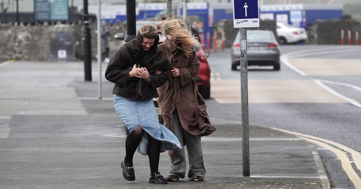
Storm Ashley: Met Eireann issues rare 6 word warning as wave 4 times height of double-decker bus recorded
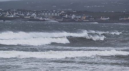
Met Eireann's words of caution came soon after a wave measuring 19.5 metres (more than four times the height of a traditional double-decker bus) was recorded off the west of Ireland
Met Eireann has issued a rare six word warning to anyone considering going outside while weather alerts for Storm Ashley remain active.
There are currently two separate Met Eireann weather warnings in place. A Status Orange alert of wind for counties Clare, Kerry, Donegal, Galway, Leitrim, Mayo and Sligo remains active until 8.00pm on Sunday while a Status Yellow warning of wind for all of Ireland will run until midnight on Monday.
On Sunday morning, Met Eireann took to social media to issue its six word warning. "Stay Back, Stay High, Stay Dry," wrote Met Eireann on X, formerly Twitter.
READ MORE - Storm Ashley: LIVE weather updates and tracker as 'explosive cyclone' batters Ireland
READ MORE - Storm Ashley: Ryanair issues warning to passengers as Ireland braces for flooding and power outages
Met Eireann's words of caution came soon after a wave measuring 19.5 metres (more than four times the height of a traditional double-decker bus) was recorded off the west of Ireland.
"19.5 meters of a wave now recorded by the M6 Buoy out West of Ireland in the Atlantic," wrote Alan O'Reilly of Carlow Weather on X. "That is 64 feet or over 4 double decker buses high! Huge seas approaching the West coast, I really hope those in areas prone to coastal flooding are prepared best they can. #StormAshley," he added.
The latest update from Met Eireann reads: "#StormAshley will bring very windy conditions today with very strong southwest winds, touching storm force on Atlantic coasts with severe gusts. Coastal flooding is likely. Showery outbreaks of rain for most, heavy or thundery at times. Staying drier in the southeast."
Met Eireann outlook:
Tonight: Continuing very windy for a time early tonight with strong and gusty southwest winds. Showery rain for many at first, though it will be drier in the south and southeast. Winds will gradually ease overnight as rain clears to scattered showers and clear spells. Lowest temperatures of 6 to 11 degrees.
Monday: Tomorrow will be a drier, brighter day with spells of sunshine and scattered showers. Turning cloudier from the west in the afternoon and evening with showery outbreaks of rain spreading eastwards. Highest temperatures of 12 to 15 degrees in moderate to fresh southwest winds, strong on Atlantic coasts.
National Outlook:
Summary: There'll with a good lot of dry weather in many areas for the next couple of days, before becoming more unsettled later in the week, then while there's some uncertainty, there's the likelihood of some drier weather for the Bank Holiday weekend.
Monday night will be rather cloudy for a time with showery outbreaks of rain continuing to spread eastwards, followed by some clear spells and a few showers into western parts. Lows of 6 to 10 degrees with winds decreasing light to moderate southerly.
Tuesday: There'll be a few showers or a little rain for a time early on Tuesday, but it'll become mostly dry and bright with good spells of sunshine. Highs of 13 to 15 or 16 degrees in light to moderate southwesterly winds.
Tuesday night with be generally dry for a time with clear spells, however it'll become increasingly cloudy from the west with a little rain and drizzle moving in from the west, mainly affecting western and southern parts, with some hill and coastal mist too. Lows of 7 to 11 degrees in mostly light to moderate southerly winds, freshening a little in western and northwestern coastal parts.
Wednesday: Wednesday will bring a good deal of dry weather to many areas and while it'll be rather cloudy overall, some bright or sunny spells will develop, mainly across the midlands and east. It'll stay rather cloudy in western and southern coastal parts though, with a little patchy light rain and drizzle at times, mainly further south. Highest temperatures of 14 to 16 or 17 degrees in freshening southerly winds.
It'll be rather blustery on Wednesday night with fresh to strong and gusty southerly winds. It'll be cloudy with just scattered outbreaks of light rain and drizzle in western and southern coastal parts at first. However, a band of heavier and more persistent rain will start to move in from the west. Lowest temperatures of 10 to 12 degrees.
Thursday: Rain will gradually spread from the west on Thursday and some of it will be heavy, with some spot flooding. While timing is uncertain, a clearance will start to extend from the from the west later on. Highest temperatures of 12 to 16 degrees in fresh to strong and gusty southerly winds, veering southwesterly and easing.
Any remaining rain will clear eastwards on Thursday night with showers following, some heavy and possibly thundery. Turning cooler as the rain clears with lowest temperatures of 4 to 8 degrees. Light to moderate southwest winds, will veer west to northwest overnight and increase fresh to strong and gusty, especially in western areas.
Friday: Friday will be breezy with sunshine and showers, some heavy and some possibly thundery, especially in the west. A cooler day on Friday with highest temperatures of 9 to 12 degree in blustery northwest winds, easing later.
The showers will tend to become isolated and mainly confined to western coastal parts on Friday night, with long clear spells developing. Lowest temperatures of 3 to 8 degrees with winds gradually decreasing light to moderate westerly.
Bank Holiday Weekend: With high pressure closeby it looks like there'll be a lot of dry weather overall. However there's still some uncertainty at this lead time and there's still a chance of some rain moving in from the northwest, though amounts should be small.
Sign up to the Irish Mirror's daily newsletter here and get breaking news and top stories direct to your inbox.
Related


Share this page
Guest Posts by Easy Branches


