


Expert pinpoints day weather warnings likely as tail end of Hurricane Ernesto heads towards Ireland
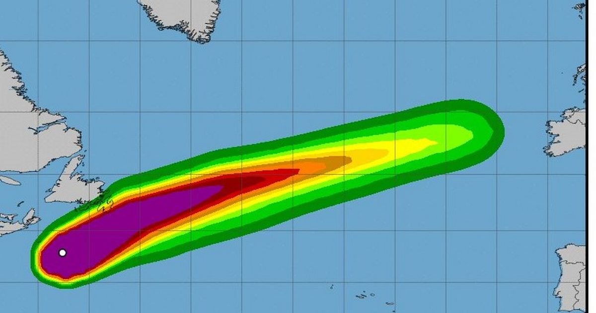
Ernesto is just about clinging onto its hurricane status and is likely to be downgraded to a storm as it makes it way east across the Atlantic and impacts on Ireland this week
Weather warnings for Ireland could well come into effect later this week as the tail end of Hurricane Ernesto makes its way towards us.
According to weather guru Alan O’Reilly of Carlow Weather, Ernesto is just about clinging onto its hurricane status and is likely to be downgraded to a storm as it makes it way east across the Atlantic and impacts on Ireland this week.
O’Reilly has suggested that winds arising as a result “could meet warning levels” on the west coast and on higher ground on Wednesday, with Thursday night also showing the potential for high winds.
READ MORE: Search for tech magnate Mike Lynch to resume after superyacht sinks near Sicily
Weather warnings or not, the wind and rain won’t be too far away over the coming days and into the weekend, although there will be some dry and sunny spells at times.
According to Met Éireann, there will be sunny spells and scattered showers on Tuesday, with the heaviest and most frequent showers arriving in the west and north of the country.
As flagged by Alan O’Reilly, Wednesday looks set to be the wildest day of the week, with “heavy and persistent rain moving eastwards over the country, bringing the chance of flooding” on Wednesday evening, with southerly winds likely to strengthen throughout the day, potentially leading to weather warnings in the worst-affected areas.
Thursday will be “largely dry with sunny spells” before “another spell of windy and very wet weather” on Thursday night.
Current signs are that the weekend will be a mix of sunshine and showers, with highest temperatures of 18 degrees. “Unsettled” conditions will then persist through Sunday and into next week.
Check out the Met Éireann forecast for the coming days below.
Tuesday
Sunny spells and scattered showers today, most frequent in the west and north, some heavy and becoming isolated later this afternoon. Highest temperatures 14 to 18 degrees in moderate to fresh and gusty westerly winds, strong at times on western and northern coasts.
Largely dry tonight with clear spells. Cloud will build from the west later with rain and drizzle in the northwest by morning. Lowest temperatures 9 to 13 degrees in light to moderate west or southwest winds.
Wednesday
Mostly cloudy tomorrow, Wednesday, with rain and drizzle across the northern half of the country in the morning, becoming drier in the afternoon. Southerly winds will strengthen through the day, increasing strong near Atlantic coasts. Highest temperatures 14 to 18 degrees.
Wet and windy Wednesday night with heavy and persistent rain moving eastwards over the country, bringing the chance of flooding, accompanied by fresh to strong and gusty southerly winds. Winds will ease westerly as the rain clears eastwards. Lowest temperatures 12 to 16 degrees.
Thursday
The last of the overnight rain and strong winds will clear from the east of the country early on Thursday morning, then the day will be largely dry with sunny spells and well scattered showers. Highest temperatures 16 to 19 degrees in mostly moderate west or southwest winds.
Another spell of windy and very wet weather will come through on Thursday night, bringing a chance of flooding in places. Lowest temperatures 10 to 12 degrees with variable winds.
Friday
The heavy rain is expected to move through Friday morning, once again clearing to sunshine and blustery showers. Highest temperatures 14 to 18 degrees.
Saturday
Sunshine and showers on Saturday, highest temperatures 14 to 18 degrees with mostly moderate westerly winds.
Outlook
Current indications are that unsettled conditions will persist through Sunday and into next week.
Sign up to the Irish Mirror's daily newsletter here and get breaking news and top stories direct to your inbox.
Related


Share this page
Guest Posts by Easy Branches


